
A rambla is a fluvial landform characterised by intermittent streams that occurs in semi-arid Mediterranean climate regions. Plants in the surrounding area cope with difficult conditions and must be able to tolerate flood periods during the rainy season and drought conditions during the summer. Moreover, they must have deep roots to resist the heavy rains in autumn. The flora that can be found in this area is the oleander (Nerium oleander), the salt cedar (Tamarix sp.), the giant cane (Arundo donax) and Spanish broom (Spartium junceum). Except for the sugar cane, they are native species.
The oleander is a shrub with long, dark green leaves and clear-pink flowers; the salt cedar has tiny, scale-like leaves on fine twigs that give a “nude” appearance and the Spanish broom is a shrub with long, whip-like twigs and small yellow flowers.
Nowadays, native species have to compete against the invasive cane, a non-native species with the ability to spread rapidly and displace the existing species. Canes spread by a thick, underground stems called rhizomes that can produce new plants and that is the reason why it is very difficult to control once established. However, they act as wind break in plain areas.
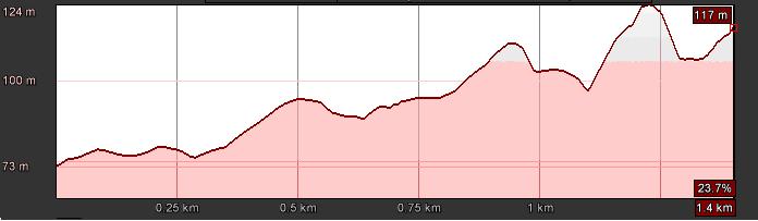
You can access this trail either from the Minasierra pathway by following the hiking trails of “Fábricas azucareras” (Sugar factories) and “Cultivos subtropicales” (Subtropical crops) or by the N-340 road branching off to the east to a farmland track which runs from the rambla Cañizares (about half a kilometre after passing the weir known as Azud de Lobres) where you will see a big aqueduct. Once you have accessed the path, you will have to negotiate the rocky river bed of the rambla. After passing a small rural cottage (locally known as cortijo), continue for approximately 300 metres (984.25 feet) where you will find a panel with information regarding the vegetation of the Tajo River. Here, the pathway comes to an end.
The Cortijo de la Presa and Escalate 5 are settlements located on the steep areas near the rambla for the exploitation of the natural resources like mining and water.
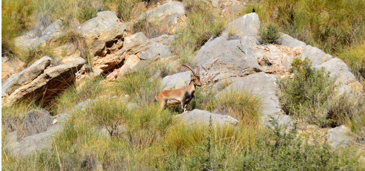
You will find panels with information regarding geology, flora and fauna: “El karst”, “El empuje de África” (The African tectonic plate), “Del material que construye las montañas” (What are mountains made of), “Los metales” (Metals), “Fauna de las Ramblas” (Fauna of the Ramblas), “La serpiente azul y verde” (The blue and green snake), “Los amantes del sol: el matorral” (Sun-loving species: the shrub”, “Fauna del matorral” (Fauna of the shrub), “Pequeños bosques para un clima duro” (Small forests in a harsh climate), “Fauna de los bosquetes mediterráneos” (Fauna of the Mediterranean copses) and “La vegetación del tajo”(the vegetation of the Tajo River).
Take the N-340 road branching off to the east to an farmland track which runs from the rambla Cañizares about half a kilometre after passing the weir known as Azud de Lobres where you will see a big aqueduct.
After passing a small cortijo, continue for approximately 300 metres (984.25 feet) where you will find a panel with information regarding the vegetation of the Tajo River. Here, the pathway comes to an end.
Just a few metres from the main road in direction to Motril, you will find the hiking trail of “Azud de los Vados”.