
The archaeological site of the rural cottage known as Cortijo de la Presa is a settlement from the Copper Age (approximately 2500-1700 years) and near it, you can find the viewpoint of Los Vados which is located next to the above mentioned cortijo in a hill overlooking the Guadalfeo riverbed and the rambla Cañizares-Escalate. Although this site is totally destroyed, you may have the opportunity to see tiny pottery remains.
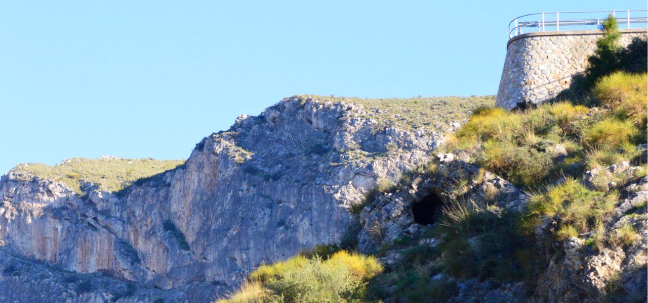
From the viewpoint you will be delighted by the views of the valley of the Guadalfeo river as well as its gorge, known as Tajo de los Vados. This place is the result of the erosion made by the river in the limestone rocks found in the mountain range of Escalate. This process started 5.5 millions of years ago as a consequence of plate tectonics movement. Due to the elevation of the terrains, the level of the sea gradually was below the course of the river which dredged down to dig out a deeper riverbed resulting in a profound gorge. All this process leads to the current breathtaking landscape.
The lower course of the Guadalfeo, where the current and famous Vega (agricultural plain) of Motril-Salobreña is found, originally was a cove delimited by the old isle of the Peñón, the promontory of Salobreña to the west and the Hill of Maraute in Torrenueva to the east. In ancient times, the sea soaked into few kilometres inland and it could reach the present village of Lobres or even farther.
You can access this trail either from the Minasierra pathway by following the hiking trails of “Fábricas azucareras” (Sugar factories) and “Cultivos subtropicales” (Subtropical crops) or by the N-340 road branching off to the east to a farmland track which runs from the rambla Cañizares (about half a kilometre after passing the weir known as Azud de Lobres) where you will see a big aqueduct. Walking along this path you will find a crossing gate that gives access to the Hydrographic Confederation divider where you will find a panel pointing out the beginning of the hiking trail.
Before starting this pathway, from the above mentioned place, you can access to a wonderful viewpoint in the nearby hill where the views out across the surrounding landscape of the Tajo de los Vados are quite breathtaking.
This route winds its way from the main path. After passing a road on the left, you have to continue the main path. After that, you will go under the aqueduct until you reach an area full of custard apples and avocados crops.
After a series of bends, you will reach a pine forest of Aleppo pines. Following the trail, you will see some access to the cottage of Panata and a stream. Then, walk a few metres until you reach a viewpoint with astonishing views of the Guadalfeo river and its agricultural plain. Afterwards, you will continue your way passing by the viewpoint.
A viewpoint from which you can see panoramic views of the Tajo de los Vados, and near it, the archaeological site of the Cortijo de la Presa which was destroyed. In the cottage called Panata, there are remains of another archaeological site also destroyed.
Information panels: “La joven vega de Motril” (The recent agricultural plain in Motril) and “El cañón de millones de años” (The canyon with millions of years).
Take the N-340 road branching off to the east to an farmland track which runs from the rambla Cañizares about half a kilometre after passing the weir known as Azud de Lobres where you will see a big aqueduct.
The path comes to an end in the N-340 road.
After few metres along the national road from Motril to Velez de Benaudalla, you will find a path called Rambla Cañizares.